P220
APRS – Automatic Packet Reporting System
This page features extracts from the official APRS website: https://www.aprs.org/
APRS is an acronym for Automatic Packet Reporting System., It was developed by Bob Bruninga WB4APR. Early experiments in the concept go back to 1984 where Bob developed a network using early Vic20 computers for tracking contestant movements on horse endurance rides. From that came a more sophisticated general-purpose information handling system.
In Australia it means that an operator can connect an APRS device to a HF amateur radio transceiver which will attempt to transmit location info in real time to any receiver nodes within range. The result is that an interested person can go to the APRS website and view on a map where that station has been and where they are now. This has important advantages for outback travellers, as it has tremendous range and is independent of other commercial mobile communications systems.
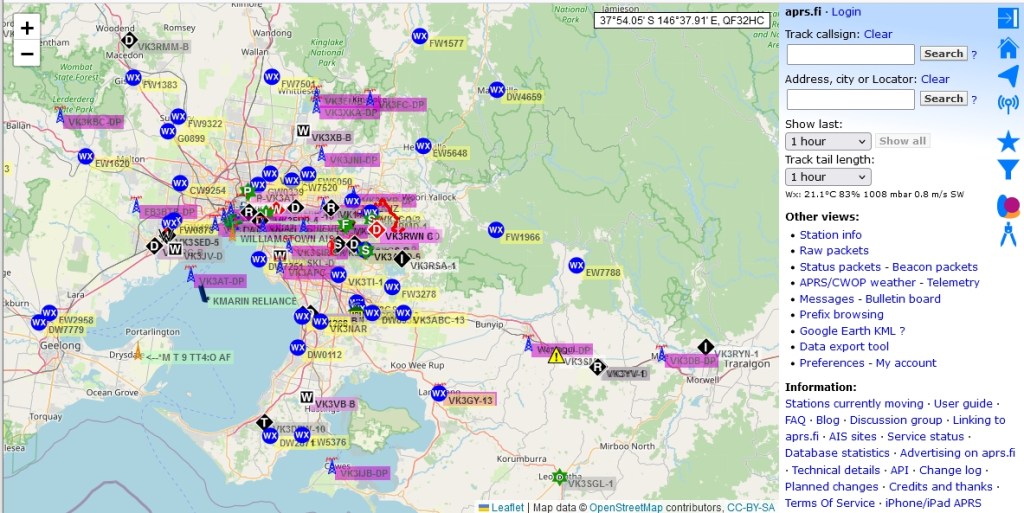
A typical location map is shown below where APRS activity is shown in the area around Melbourne Australia. This map allows the viewer to enter the callsign of a participating operator to view their past and present location data.
The Automatic Packet Reporting System was designed to support rapid, reliable exchange of information for local, tactical real-time information, events or nets. The concept, which dates back to the mid 1980’s, is that all relevant information is transmitted immediately to everyone in the net and every station captures that information for consistent and standard display to all participants. Information was refreshed redundantly but at a decaying rate so that old information was updated less frequently than new info. Since the primary objective is consistent exchange of information between everyone, APRS established standard formats not only for the transmission of POSITION, STATUS, MESSAGES, and QUERIES,

it also establishes guidelines for display so that users of different systems will still see the same consistent information displayed in a consistent manner (independent of the particular display or maping system in use). See the original APRS.TXT. The two images below should give you an idea of the kinds of information available to the mobile operator on his APRS radio.
THE GOAL IS COMMUNICATIONS and LOCAL INFO UPDATE, NOT JUST TRACKING!
APRS was never intended to be just a vehicle tracking system (GPS was added in the 1992 time frame when GPS became affordable). APRS is much more. See the Kenwood mobile display above. This is the STATION LIST which shows the nearest 100 stations heard. . In this case, not only are the two stations of AB9FX nearby, but also his current VOICE operating frequency is visible. Also, we can see that this radio is in OPERATING range of three voice repeaters that are also identifying themselves as objects on APRS as the locally recommended voice operating channels.
UNIVERSAL TEXT MESSAGING FOR AMATEUR RADIO
Not only can APRS users text-message each other live, but they can also text-message with many other cross-platform media. There is an initiative to cross connect ALL consumer type hand-held wireless devices to the APRS system.
any two radio amateurs can text-message callsign-to-callsign completely independent of the type of device. They can use cell phones, pagers, DTMF HT’s or just about any other kind of device. See the web page: Universal Text Messaging Initiative
Other useful information about APRS
How APRS Works: https://how.aprs.works/
A text file on the history of APRS: https://www.aprs.org/APRS-docs/ARTICLES.TXT
Location Map key: (based on an I.P Address approximation) https://aprs.fi
